How Does GPS Work? Satellites, Atomic Clocks and a Little Help From Einstein
A GPS receiver doesn't send anything to space: it times signals from several satellites, turns those times into distances and finds where they meet. Atomic clocks and a relativity correction keep the math honest.
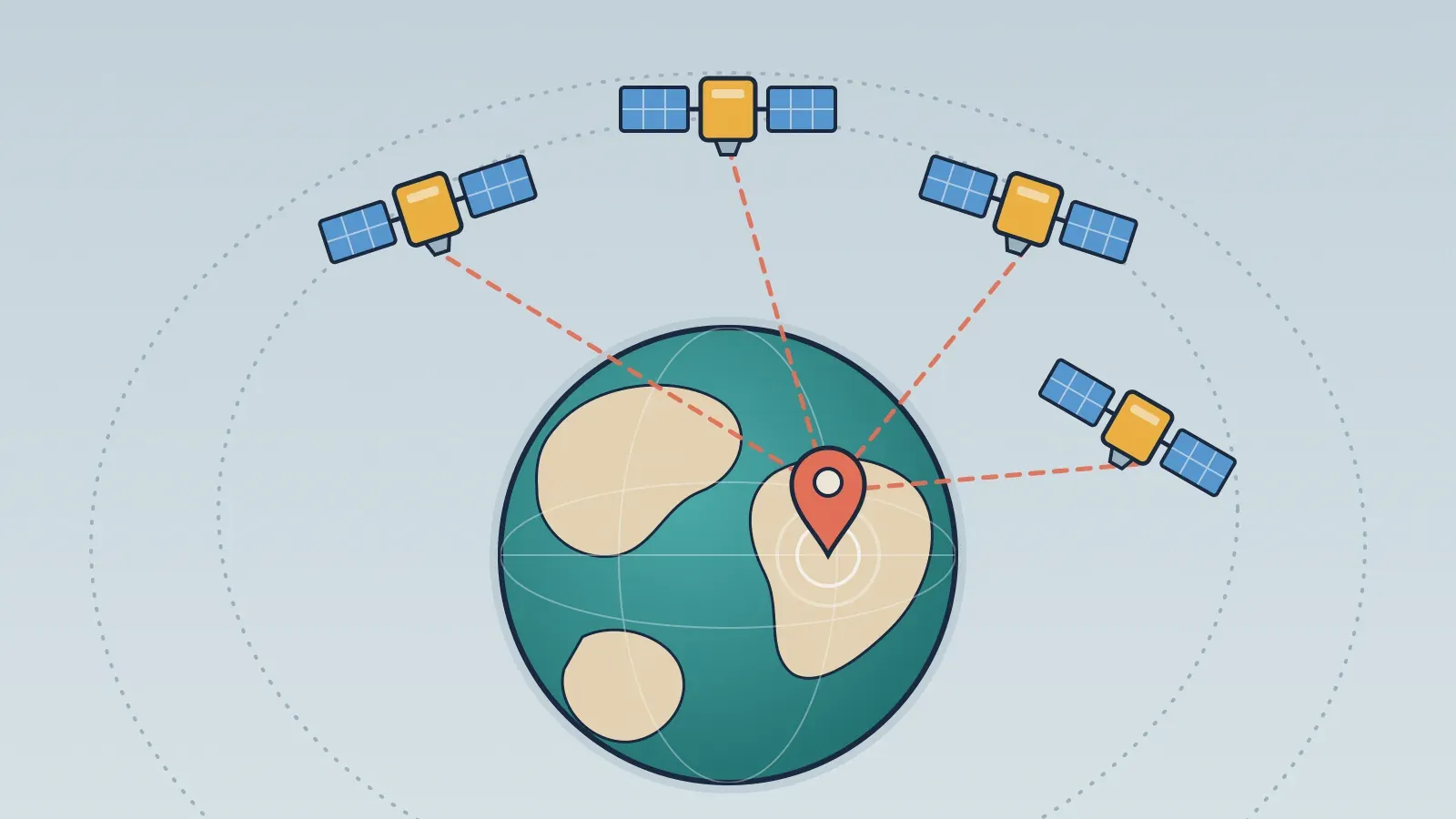
GPS works like a giant stopwatch. About 30 satellites constantly broadcast signals carrying the exact time and their own position. The receiver in your phone or car measures how long each signal took to arrive, converts that delay into a distance and, by combining distances to at least four satellites, works out where it is.
How many GPS satellites are there, and where are they?
GPS stands for Global Positioning System, and it is operated by the United States. The constellation was designed around 24 orbital slots, four in each of six evenly spaced planes tilted 55 degrees to the equator. In practice, around 30 satellites are usually in service, which leaves room for maintenance and failures.
They fly about 20,200 km (12,550 miles) up, in what is called medium Earth orbit, and circle the planet roughly once every 12 hours. They are not geostationary: they cross the sky, rising and setting like very slow stars. The layout was chosen so that, from almost anywhere on Earth, at least four of them are always above the horizon.
How does signal travel time become distance?
Each satellite continuously transmits a radio signal that says, in essence, which satellite it is, where it is and the instant the message left. The receiver notes the instant the message arrived. The gap between the two times is the signal's travel time; multiply it by the speed of light and you get the distance to that satellite.
One distance on its own doesn't say much: it only places the receiver somewhere on an imaginary sphere centered on the satellite. Two spheres narrow the options to the circle where they intersect; three narrow it to a couple of points. This method, which uses distances rather than angles, is called trilateration, not triangulation, which measures angles.
Notice that your phone sends nothing to space. GPS is a one-way street: satellites only talk and receivers only listen. That's why the system can serve any number of users at once, and why calculating a position doesn't require an internet connection. The map you see on the screen usually does.
Why do you need at least four satellites?
In theory, three distances would be enough to pin down a point in space. The trouble is the receiver's clock. The satellites carry atomic clocks, but the clock in a phone is far less precise. And in this calculation, small slips are expensive: light travels about 30 cm (roughly a foot) in a billionth of a second. A clock error of just one thousandth of a second would shift the position by almost 300 km (about 186 miles).
The fix is to treat the clock error as one more unknown. With a fourth satellite's signal, the receiver adjusts its own clock until all the distances meet at a single point. Step by step, it looks like this:
- The satellite sends its position and the exact time of transmission.
- The receiver records the time of arrival.
- The time difference, multiplied by the speed of light, gives the distance to that satellite.
- With four or more distances, the receiver calculates latitude, longitude and altitude, and corrects its own clock along the way.
There are almost always more than four satellites in view, and the extra measurements make the result more reliable. According to teaching material from The Ohio State University, a simple handheld receiver can find its position to within 5 to 10 meters (about 16 to 33 feet), and more sophisticated techniques reach centimeter level.
Where does Einstein's relativity come in?
For all this to work, the rate of the onboard clocks has to be known to within 20 to 30 billionths of a second. That's where an effect that once seemed like a lab curiosity shows up: time doesn't pass at the same rate up there and down here. Two effects predicted by Einstein pull in opposite directions:
| Effect | Cause | Daily difference compared with the ground |
|---|---|---|
| Special relativity | The satellite's speed, about 14,000 km/h (8,700 mph) | Clock runs about 7 microseconds slow |
| General relativity | Weaker gravity at orbital altitude | Clock runs about 45 microseconds fast |
| Net result | Both effects combined | Clock runs about 38 microseconds fast |
That sounds tiny, but left uncorrected, position errors would grow by about 10 km (6 miles) a day. So the satellite clocks are set before launch to tick at a slightly lower frequency than the reference clocks on the ground. Once in orbit, seen from the ground, they keep the right pace, and receivers apply small extra corrections using data the satellites themselves broadcast.
Is GPS the only satellite navigation system?
No. GPS has become shorthand for location, but it's just one of several satellite navigation systems, known collectively as GNSS. According to GPS.gov, the U.S. government's official GPS website, there are three other global systems and two regional ones:
- GLONASS, run by Russia, with 24 or more satellites.
- Galileo, run by the European Union, which began initial services in 2016.
- BeiDou, run by China, which became fully operational in 2020 with 35 satellites.
- NavIC, run by India, and QZSS, run by Japan, which serve only their own regions.
They all rely on the same principle of timing signals. A receiver that can use more than one system sees more satellites at once, which helps in places where much of the sky is blocked, such as among tall buildings.
There's a historical twist here. For centuries, navigators found their position by measuring the angles of stars that, seen from the ground, twinkle because of air turbulence. GPS swapped stars for satellites and angles for time. And since the clock was one of the unknowns, the receiver finishes the math knowing the exact time too, which your phone converts to the local time zone and the right side of the International Date Line. Only at the very end is the blue dot drawn on a flat map, with the same distortions that make Greenland look huge.